
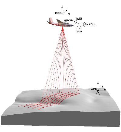
LIDAR, Light Detection and Ranging, is a technology that uses a laser to measure distance to and other properties about a certain target. The remote sensing technology uses a laser to light up the target. This is often used in archaeology, geography, geology, geomorphology, seismology, forestry, and remote sensing.
http://www.google.com/imgres?imgurl=http://forsys.cfr.washington.edu/JFSP06/images/lidar_schematic.jpg&imgrefurl=http://forsys.cfr.washington.edu/JFSP06/lidar_technology.htm&usg=__oZFLvXNvl2EFdkZ60eJ7bgcReQw=&h=433&w=400&sz=16&hl=en&start=2&sig2=8XHOKB1S6SG2nmJBqO9zMg&zoom=1&um=1&itbs=1&tbnid=3ZaeSx97GfpEXM:&tbnh=126&tbnw=116&prev=/images%3Fq%3DLIDAR%26um%3D1%26hl%3Den%26rlz%3D1T4ADFA_enUS340US340%26tbm%3Disch&ei=1vnwTdn7DpCFtgfDwLCdAw
No comments:
Post a Comment